

François Sémécurbe is defending his PhD thesis : Analysis of the spatial distribution of human settlements : Contributions and limitations of multi-scale and trans-scale indicators
The defense will take place in Besançon at the University of Franche-Comté at Salon Préclin, UFR SLHS on september 25th at 2 pm.
This work was directed by Cécile Tannier, Senior researcher at CNRS (French National Centre for Scientific Research).
Defense jury
Elsa Arcaute - Associate professor, CASA, University College London Giovanni Fusco - Associate researcher "HDR" at CNRS,...
- Details
- Category: Dissertation Defence
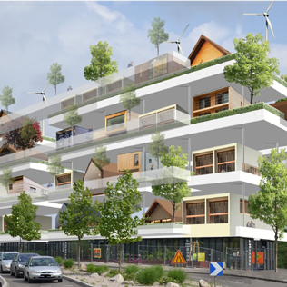
Jean Houssemand is defending his PhD thesis : Conceptualization and evaluation of a typology of vertical housing concept for sustainable urban planning
The defense will take place in Dijon at the University of Burgundia at the Maison des Sciences de l'Homme, Salle des Thèses (6 Esplanade Erasme), on february 14th at 14pm.
This work was directed by Jean-Philippe Antoni, Professor at the University of Burgundy, laboratory ThéMA.
Defense jury
Denis Bocquet, Professor at the National School of Architecture of Strasbourg
Éric Charmes, Director of Research at...
- Details
- Category: Dissertation Defence
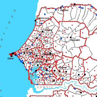
Seydou Ba is defending his PhD thesis : The issue of viability and socio-economic development in institutional territories facing administrative divisions in Senegal
The defense will take place in Besançon at the Salon Preclin, UFR SLHS on decembre 16th at 10am.
This work was directed by Alexandre Moine, Professor at the University of Franche-Comté, laboratory ThéMA.
Defense jury
Frédéric Giraut, Professor at the University of Geneva, Switzerland
Jean-Christophe Gay, Professor at the University of Sophia-Antipolis, Nice, France
Stéphanie Lima, Lecturer at the INU...
- Details
- Category: Dissertation Defence
An interdisciplinary research work between urban planning and language sciences now published in the journal Urban Studies
Thomas Buhler, laboratory ThéMA and Virgnie Lethier, ELLIADD (University of Franche-Comté) present a new method which opens up research perspectives for the coming years.
For several decades now, French cities - like many others around the world - regularly publish urban planning documents in which their strategies are expressed for the next 5, 10 or even 15 years. These documents concern particular themes (transport, land use regulations, housing, etc.). Begun...
- Details
- Category: Publication and Output
Maxime Colomb is defending his PhD thesis entitled "Multi-scale simulation of realistic forms of residential development from the parcel to the metropolitan area".
The defense will take place at the Université Paris Est, in the IGN (Institut Géographique National), 73 avenue de Paris, Saint Mandé on September 27th, 2019.
This work was directed by Julien Perret, Senior researcher, IGN (French national Geographic Institute) and Cécile Tannier, Senior researcher at CNRS (French National Centre for Scientific Research), Laboratoire ThéMA and co-directed by Mickaël...
- Details
- Category: Dissertation Defence
Badra Merrad Benyamina is defending her PhD thesis "Space Movements and Mutations in Algiers" in Dijon
The defense will take place at the MSH of Dijon on July 1st at 14h30.
This work was directed by André Larceneux, Emeritus Professor at the University of Borgogne and co-directed by Tahar Baouni, Professor at the Ecole Polytechnique d’Architecture et d’Urbanisme (EPAU-Alger), laboratoire VUDD
Defense jury
Corinne Blanquart, Director of Research at IFSTTAR,Planning, Mobilities and Environment Department
Marie-Hélene Massot, Professor at the University...
- Details
- Category: Dissertation Defence
Valentine Judge is defending her PhD thesis "Machine Learning for Land Use Change Analysis and Modelling. An exploration of urban development on the French-German border area"
The defense will take place in Besançon at the Salon Preclin, UFR SLHS on July 16th at 3pm.
This work was directed by Jean-Philippe Antoni, Professor at the University of Borgogne, laboratory ThéMA and co-directed by Olivier Klein, Associate researcher at the LISER Institute, Luxembourg.
Defense jury
Francisco Escobar, Professor at the University of Alcala, Spain
Giovanni Fusco, Associate...
- Details
- Category: Dissertation Defence
Olivier Bonin, researcher IFSTTAR at LVMT (Laboratoire Ville-Mobilité-Transport, Champs-sur-Marne), is defending his Accreditation to supervise research at the laboratory ThéMA.
The defense will take place on may the 27th at 2 pm, at the " Grand Salon" (18, rue Chifflet, UFR SLHS).
Geography has since antiquity used cartography to describe the shape of the Earth and its population. Indeed, cartography is an analogical model of the world particularly suited to the description of shapes, spatial arrangements and spatial relationships, i.e. information of a...
- Details
- Category: Dissertation Defence
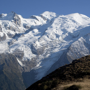
An article published in Nature Scientific Reports: Huge decrease of frost frequency in the Mont-Blanc Massif under climate change
Benjamin Pohl, Daniel Joly, Julien Pergaud, Jean-François Buonchristiani, Paul Soare & Alexandre Berger, Nature Scientific reports volume 9, Article number : 4919 (2019)
https://www.nature.com/articles/s41598-019-41398-5#Abs1
This study co-signed by 5 members of the laboratory...
- Details
- Category: Publication and Output
PixScape software, devoted to the modelling of landscape visibility, is published in the journal “Transactions in GIS”
PixScape software proposes to integrate a large set of functions for modeling landscape visibility while remaining interfaced with GIS software. This software can be used to perform a complete landscape assessment by computing a wide range of original landscape metrics. It performs tangential analysis in addition to viewshed analysis, which can produce more realistic outcomes. Because landscape visibility analysis over large areas implies significant computation time, the...
- Details
- Category: Publication and Output