

He will be assisted by Cécile Tannier and Thomas Thévenin, appointed as deputy directors.Having joined the laboratory in 2019, Samuel Carpentier-Postel is Professor. He succeeds Jean-Christophe Foltête, who held this position for 12 years.
- Details
- Category: Diffusion
This thesis named "Analysis, modeling and simulation of road network morphogenesis based on geohistorical data: understanding past patterns to plan future cities" was directed by Claire Lagesse and Cécile Tannier.
The defense will take place in the UFR SLHS (salon Préclin) in Besançon, on december the 15th.
You will also be able to attend the defense by videoconference. If you would like, please contact Hanae El Gouj : This email address is being protected from spambots. You need JavaScript enabled to view it.
Defense jury
Anne Bretagnolle -...
- Details
- Category: Dissertation Defence

The defense will take place in the UFR SLHS (salon Préclin) in Besançon, on november the 23th.
This work was directed by Jean-Christophe Foltête and Emeline Comby.
Defense jury :
Jean-Christophe FOLTETE, Professor, University de Franche-Comté
Emeline COMBY, Associate researcher, University Lumière Lyon 2
Youssef DIAB, Professor, University Gustave Eiffel
Pascal MARTY, Professor, CNRS-Maison Française d’Oxford and University Paris 1 Panthéon-Sorbonne, Rapporteur
Magalie FRANCHOMME, Associate researcher, University de Lille
Corinne LARRUE, Emeritus professor,...
- Details
- Category: Dissertation Defence
Sima Saadi is defending her PhD thesis on april 19th, at 9 am In ThéMA main meeting room, 4 Boulevard Gabriel, 21000 Dijon.
This thesis was directed by Jean-Philippe Antoni, Geographer, University Professor, at the University of Burgundy, and Co-directed by Hossein Karimzadeh, Urban planner, University Professor, at the University of Tabriz.
Defense jury :
Dominique Badariotti, Professor, University of Strasbourg, France (President)
Saeed Zanganeh Shahraki, Associate Professor, Faculty of Geography, University of Tehran, Iran
Antoine Paccoud, Research Scientist, Luxembourg...
- Details
- Category: Dissertation Defence

Claire Regnier is defending her PhD thesis the 14th december 2022 at 14 at the IRTS of Franche-Comté in Besançon.
This work was directed by Alexandre Moine, géographer, professor of University of Franche-Comté and Christian GUINCHARD, sociologist, Senior lecturer at the University of Franche-Comté.
Defense jury :
Erwan Becquemie, Director General of Hygiène Sociale of Franche-Comté
Olivier David, Professor, University of Rennes 2
Philippe Lyet, Sociologist, Askoria, Rennes
Jean-François Thémines, Professor of University of Rennes 2
Abstract :
The...
- Details
- Category: Dissertation Defence
The defense will take place in Champs-sur-Marne at the Ecole Nationale des Ponts et Chaussées (salle B203) on april the 1rst.
This work was directed by Alain L'Hostis and Pierre Frankhauser.Funding : Ecole des ponts ParisTech-ENPC / Efficacity-Institut de Recherche & Développement pour la Transition Énergétique de la Ville.
Defense jury :
Alain L'HOSTIS, Senior researcher, University of Gustave Eiffel
Pierre FRANKHAUSER, Emeritus professor, University of Franche-Comté
Olivier BONIN, Senior researcher, University of Gustave Eiffel
Cristina PRONELLO, Professor...
- Details
- Category: Dissertation Defence

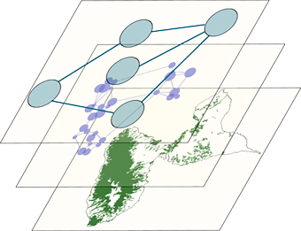
Cécile Tannier presents the Fractal model and its impact on how urban forms and spatial organisation are approached in urban studies and planning. Reflecting critically on scale invariance and optimality, she shows how and why fractal models enable us to better understand how space is organised through scales and how urban planning can modify this spatial organisation in a fractal manner, accounting for the effects of distance and scale dependence.
See the video on the YouTube channel: https://www.youtube.com/channel/UCbXVD-lwollN5yxX_0J-hbg
- Details
- Category: Diffusion
The defense will take place the 7th december at 14:30 at the "Grand salon", UFR SLHS, 32 rue Megevand in Besancon.
This work was co-directed by Jean-Christophe Foltête (ThéMA) and Stéphane Garnier (Biogéosciences).
Funding: CIFRE thesis with the company ARP-Astrance, Paris
Defense jury
Stéphanie Manel, Professor, EPHE, UMR CEFE, Montpellier
Eric Petit, Director of Research, INRAE, UMR ESE, Rennes
Laurence Després, Professor, Université Grenoble Alpes, UMR LECA, Grenoble
Laurent Bergès, research ingenior, INRAE, UR LESSEM, Saint-Martin-d’Hères
Hervé Moal,...
- Details
- Category: Dissertation Defence

When new lifestyles disrupt daily mobility in England
By exploring data relating to England from the UK National Travel Survey between 2002 and 2017, this research led by Benjamin Motte-Baumvol was able to refine the analysis of daily mobility usually carried out in France (where surveys are based on one “typical day”) by considering the variability of travel over a whole week, which reflects our increasingly fragmented lives more authentically.
Thanks to new “remote” practices enabled by the development of telework and online shopping, we can perform our activities in a greater...
- Details
- Category: Diffusion

The defense will take place in Dijon at the University of Burgundy on december 14th
This work was directed by Thomas Thevenin, Associate researcher "HDR" ThéMA and Yves Richard, Associate researcher "HDR", Biogéoscience-CRC.
The defense can be followed online by : http://desktop.visio.renater.fr/scopia?ID=727610***8300&autojoin
Code d'accès : 8300 (terminer par #)
Defense jury
Houet Thomas, Director of Research "HDR" CNRS, LETG, Rennes
Masson Valéry, Director of Research HDR, GMME/VILLE, CNRM, Toulouse
Cantat Olivier, Associate researcher, LETG,...
- Details
- Category: Dissertation Defence